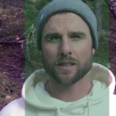
Video analytics systems
Development of algorithms and software for the intellectual analysis of digital images in the field of video surveillance and security: recognition, detection, visualization of objects or panoramas, analysis and image search, etc.
Related technologies
- Machine learning
- Internet of things
Scope of applicability
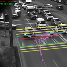
Video Surveillance and SecurityTasks
- Analysis of a large number of objects
- Continuous operation without loss of quality
- High speed and accuracy of measurements
- Automatic image analysis
- Automatic decision-making
- Performance of additional functions as the task may require
Advantages
- Improving the speed and quality of control by eliminating the “human factor”
- multitask capability (detection, classification, automated decision-making, matching search, etc.)
- Reduction of labor costs and other costs of traditional verification methods
- Guaranteed detection of emergencies and violators; the database search option.
Our project approach
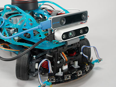
We develop algorithms and software for processing video streams and images to solve a wide range of tasks, depending on the application area and the customer’s goals. A separate area is the development and optimization of software solutions for embedded systems with limited computing capacities.Technical vision systems
Intelligent analysis of digital images from industrial cameras to improve the accuracy and efficiency of equipment and processes, often used as a component of larger systems and focused on specific application tasks.
Related technologies
- Machine learning
- Industrial Internet of Things
Scope of applicability
- Video Surveillance
- Industrial automation
- Robotics
- Vehicle control systems
- Medical information systems
Tasks
- Analysis of a large number of objects
- Continuous operation without loss of quality
- High speed
- High measurement accuracy
- Automation of verification and control
Advantages
- Improving the speed and quality of control
- Stable quality due to the exclusion of the “human factor”
- Multi-task capability (detection, classification, identification of objects, automated decision-making, etc.)
- Reduction of labor costs and other costs on traditional verification methods
- Optimization of business processes and guarantee of their effectiveness
Our project approach
We carry out a full cycle of hardware and software development; develop and adapt machine vision algorithms to the performance targets. Orientation to the target software and hardware platform improves the performance of algorithms. In the development, we use machine- learning and deep-learning approaches.Data analytics
Data analytics enables the examination of large amounts of heterogeneous data in order to discern patterns and gain insights that inform decision-making.
Related technologies
Crowdsourcing, data blending and integration, machine learning and neural networks, predictive analytics, simulation modeling, mathematical modeling, statistical analysis, data miningScope of application
Public sector, banking, IT, manufacturing, healthcare, retail, science, marketing, and others.Tasks
- Matching search and hidden pattern detection
- Process and equipment diagnostics
- Process modeling
- Event and indicator prediction
- Decision-making support
Advantages
- Business process optimization
- Decision-making efficiency improvement
- Equipment productivity increase
- Prevention of events and situations: equipment failure, fraudulent operations, etc.
- Financial performance improvement
- Business competitiveness increase
Our approach
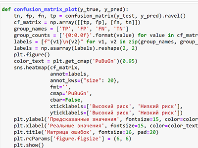
The ISSDP Laboratory is engaged in the development of systems for the collection and processing of large amounts of data, with a view to solving problems that are not amenable to conventional solutions. The projects utilize data from a range of heterogeneous sources, including digital images, laser scanning point clouds, sensor data, and audio data, among others. The methods of intelligent image analysis, machine learning, predictive analytics, mathematical modeling, etc. are applied to work with them.
Data analysis technologies used:
- Augmented analytics;
- Augmented data management;
- Natural language processing and conversational analytics;
- Graph analytics;
- Commercial AI and machine learning.
Multisensory systems, IIoT
We develop systems for collecting, transmitting and analyzing data from transmitters and sensors for integrated control of equipment and processes. As “input devices” of primary information, video cameras, gyro sensors, barometers, sound, temperature, and pressure sensors, etc. are used. “Dark” data are conveyed to a cloud computing service for interpretation and analysis. The result is visualized on the cameraman's workstation in the form of formalized data on the status of key processes.
Related technologies
- Machine learning
- Internet of things
Scope of applicability
It is used in production, in the operation of critically important engineering structures (pipelines and gas pipes) in difficult for access conditions, wherever comprehensive monitoring of equipment or processes is required.
Tasks
- Collection and processing of a large amount of heterogeneous data
- “Instant cut” of information simultaneously throughout the system
- Continuous monitoring of key parameters in the real-time mode
- The possibility to optimize system management using additional functions of analytics including the predictive one.
Advantages
- Enhancement of the quality and effectiveness of monitoring of the state of objects
- Ability to control the operation process using forecasts and recommendations
- Capacity to prevent critical situations before they take place
- Reduction of time and financial costs for traditional control methods
- Reducing the costs of operating and repairing the system
Our project approach
- Solving complex engineering problems in the development of data-acquisition units with special requirements for the performance, accuracy, cost, energy consumption, etc.
- Development of intelligent embedded software for preprocessing, data compression, and optimization of equipment operating modes
- Enhancement of the speed of data collection and transmission processes based on boundary computing: data processing is performed not in the data center, but directly on the IIoT monitoring devices.
Machine learning technologies
A system for collecting and processing data on the state of equipment or processes based on mathematical models and algorithms that allow to build predictive analytics based on historical data on the system functioning.
Related technologies
- Technical vision systems
- Video analytics systems
- Internet of things
Scope of applicability
Banking, IT, retail, industry, logistics, agriculture and crop production.Tasks
- Monitoring the status of equipment and processes
- immediate interpretation of large amounts of data
- Decision-making support
- Forecast of emergencies, reduction of risks
- Assistance in solving applied problems
Advantages
- Improving the efficiency of parameter monitoring
- Reduction of the decision-making time
- Reduction of the number of emergencies due to their forecasting
- Reduction of the equipment repair and maintenance costs
- Identification of bottlenecks and optimization of business processes for the increase of the rate and efficiency of the company’s operation
- Development focused on the application tasks of a particular company
Our project approach
We use a wide range of machine learning algorithms to achieve customer goals: from decision trees to ultra-precise neural networks. We have rich experience in the work on the analysis of the video stream using machine learning algorithms. If you need to implement solutions on embedded platforms, we transfer resource-intensive solutions to platforms with limited computing capacities.
Autonomous transport
A vehicle that is entirely autonomous and operated driverless using various sensors (cameras, lidars, radars, etc.) and computer algorithms.
Related technologies
- Vision systems
- Video analytics
- AI technologies
- Industrial Internet of Things
- Data analytics
Scope of application
- Industry, warehousing, and trade
- Transport industry
- Emergency management
- Environmental monitoring
Tasks
- Map construction and orientation
- Search for the shortest path to a point on the map
- Avoidance of dynamic obstacles
- Recognition and reaction to various signs and attributes of the road environment
- Construction of overview images
Advantages
- Road safety improvement
- Transport company cost reduction
- Transport cost reduction
- Increased driver comfort, especially on long journeys
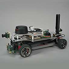
Our approach
For the Laboratory staff, intelligent control systems for unmanned transport represent an area of interest, combining modern technologies for the acquisition, processing, and transmission of data from a range of sensors in conjunction with simulation modeling methods.
The Laboratory employs an interactive model of an autonomous vehicle to facilitate the instruction of technologies for the development of unmanned vehicles at the ADAS 4 level. The model illustrates the functionality of all principal components and systems employed in the construction of operational autonomous vehicles. A training course has been developed based on the aforementioned hardware and software platform.
Through engagement with the training material, learners will not only gain a comprehensive understanding of unmanned vehicle control but will also be able to contextualize current technological trends in the field of information acquisition, processing, analysis, and transmission. As a result, they will be equipped with the knowledge and skills to develop innovative information systems of a different kind.
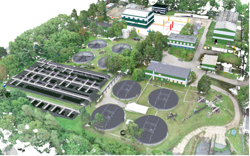
BIM design
Building Information Modeling (BIM) is a comprehensive digital representation of a building, created through the collection and complex processing of a multitude of data types, including architectural, design, technological, economic, and other information. It encompasses the interconnections and dependencies inherent to a building, as well as a set of measures designed to facilitate the management of the building's life cycle.
Related technologies
- 3D visualization
- Laser scanning and photogrammetry
- Robotics (using a UAV to take digital images of the site)
Scope of application
All site life cycle phases: design, construction, repair, operation and management, reconstructionTasks
- Inclusion in the model of data for all parties involved in the work (designers, estimators, builders, customers, regulators, etc.)
- Automated generation of design and estimating documentation based on the model and updating as the model changes
- Integration of the model with calculation systems, possibility of site inventory, calculation of necessary supplies, project stages, and costs
Advantages
- 3D design: visualization of technical solutions
- Optimization of the work of experts responsible for the implementation of different sections
- Possibility of alignment of different design sections with each other
- Control of estimates and reduction of construction time
- Reliable planning of design and construction time and cost
- Elimination of errors in pre-construction documentation, improvement of construction quality
Our approach
The Laboratory solves non-standard BIM tasks for clients.
The development of digital design methods entails the creation of novel software tools for current projects, such as software for the processing of extensive volumes of laser scanning and photogrammetry data. Additionally, new methods are devised, including the superimposition of a perfect and realistic building model for the monitoring of construction progress. In certain instances, software is developed based on these methods, for instance, for the automation of design processes and the preparation of design and working documentation.
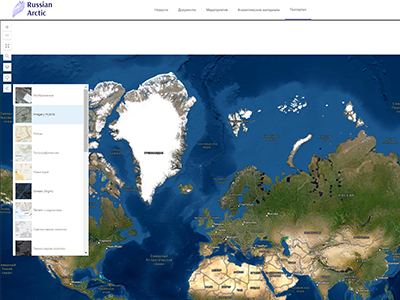
Geoinformation systems
Geoinformation systems (GIS) processes, analyzes, and visualizes data that is spatially coordinated in order to enhance the efficiency of management processes, data storage and presentation, and data processing and analysis for the purpose of decision-making support.
Related technologies
- Computer cartography
- Database management
- Big Data analytics
Scope of application
Healthcare, criminology, ecology, agriculture, meteorology, oceanography, navigation, land management, and others.Tasks
- Technical: acquisition, processing, visualization, and distribution of spatial and coordinate data; integration of data and knowledge about the territory
- Scientific and practical: inventory, analysis, modeling, prediction, environmental management, and spatial organization
Advantages
- Spatial data cartographing for the convenience of working with the system
- Integration of data from various sources into a single dataset
- Automation of data loading, presentation, and analysis processes
- Automation of work with maps, option to create 3D terrain models